Page 1 of 1

PostPosted: Fri May 25, 2007 4:37 pm
by ardypilot
There are heaps of complicated, long winded FS flight guides strewn across the net which loose your interest after a few lines of reading. I thought I would create a small thread here with a few simple flight ideas that I have discovered myself, that require little or no planning, yet yield enjoyable results.

Firstly- Greymouth:

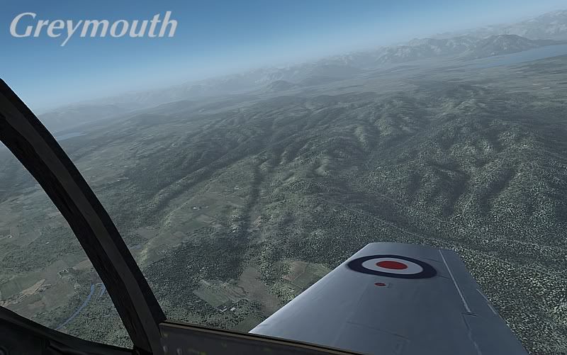
For a stunning surprise in fs2004, take a flight from Greymouth (NZGM) around the nearby valleys. Set the time to 8am, season to 'Fall' and weather to 'clear' with 30nm visibility.

The area looks amazing in the early morning light, with the sunlight casting many shadows over the terrain, which is particularly stunning with RBE's mesh and landclass addons.

The "simple pleasure' here is the grunty roar of the old school warbird tearing apart the peaceful sky of the quiet west coast. I found it especially enjoyable in the VC mode, looking out of the glass canopy cockpit as I zipped around at around 2000 feet.

I hardly ever fly in this location, but discovered its beauty accidentally today when taking the new ZK-TAG Mustang up for a spin.

Other simular aircraft, such as the RealAir Spitfire and Alphasim Harvard are also perfect for the flight. Hokitika (NZHK), Great Barrier Island (NZOX) and Coromandel (NZCX) are all equally as good locations to complete this flight.

Enjoy, and feel free to add your own ideas by posting a reply! :thumbup:

PostPosted: Fri May 25, 2007 5:05 pm
by ZK-Brock
Yip nice one Trolly. I've done a few flightsim X-countries to Nelson via Murchison and Lake station, that's a cool sim trip.

PostPosted: Mon Aug 27, 2007 6:28 pm
by ardypilot
Cook Straight Crossing
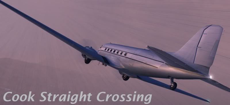
Start at Wellington International (NZWN), and set yourself up with some stormy weather theme, typical in the capital. Set the time to early evening, which will give the cloudy skies a pleasant orange or pink tint as the sun begins to set on the flight.Jump into an old cargo plane, the default FS9 Douglas DC3 is perfect, and without any maps or radio navigation aids, set out over the Cook Straight and aim for the South Island.With no autopilot, blustery turbulence and low visibility, you should have quite a struggle crossing the stretch of water, but the ‘simple pleasure’ will come in the form of finally seeing landfall and getting your aircraft down on the ground. There are a few airports which dot the head of the mainland, being Kaikoura (NZKI), Omaka (NZOM), Woodbourne/Blenheim (NZWB), Picton (NZPN) and Nelson (NZNS), most of which are suitable for a DC3 type aircraft with a low payload.

Enjoy the mission, and try and snap a screenshot of a lightning strike for an added challenge!

PostPosted: Mon Aug 27, 2007 6:34 pm
by ardypilot
The Good Old Days


There’s nothing like feeling the wind in your hair, even in FS. For this flight, you will need a bi-plane with a decent virtual cockpit. There are dozens available, both freeware and payware, but I would recommend the Warwick Carter Tiger Moth or Robert Sanderson’s Boeing Stearman.

Set the time to mid summer, add light turbulence under weather, and set the location to your favourite coastal airfield, Timaru (NZTU) and even Auckland International (NZAA) make good starting points (although you may wish to set the modern AI traffic you have installed to 0% for this flight).

Switch to the VC view mode, take off and follow the coastline in any direction you wish, sticking at between 1000 and 3000 feet, allowing the turbulence to bounce you around a little as you gaze at the shoreline below you.

The simple pleasure here is the basic feeling of realistic flight, where you don’t need to worry about your instruments or controls too much and can sit back and enjoy the view- low and slow, without getting blurry scenery.

A particular favourite route of mine, (being a bias Aucklander) is to take off from NZAA, and follow the northern shoreline of the Manukau Harbour towards the Tasman Sea. Once I reach the harbour entrance, I bank to the right over the Waitakere ranges and follow the coastline north, above Piha and Murawai, before picking a beach near the entrance to the Kaipara Harbour to touch down upon.

PostPosted: Mon Aug 27, 2007 6:40 pm
by ardypilot
Aero Club Local Tour


If you have a lot of spare time and can't think of anywhere to fly, grab a light aircraft used by your local aeroclub (Cessna 152, Piper Warrior or some other small prop) and create your own cross country VFR tour around your local airfields!

Just set the route up via the flight planner on the main FS2004 "Create a Flight' screen, then use your GPS for degree headings, and follow roads, railways, and/or river courses across the countryside, make a touch-and-go landing at your destination, then continue on to the next.

Depending on how greater distance you choose to "hop' (20-40 miles is a good average), you may wish to make a full stop landing to top up your fuel. The route that I have flown in FS around the Bay of Plenty was Ardmore (NZAR), Waiheke Island (NZRV), Thames (NZTH), Tauranga (NZTG), Whakatane (NZWK), Rotorua (NZRO), Matamata (NZMA), Mercer (NZME), then back to Ardmore again. Cruising at around 110 knots, this took me nearly 2 and a half hours, but if you focus on the flying more than your clock- the time flies by!

The simple pleasure gained from this experience is recreating the feeling of an aero club student, having a relaxing tour around your local area. Nothing special, just an enjoyable time killer winkyy.gif

PostPosted: Tue Sep 04, 2007 6:10 pm
by Florian_S
These tips will come in very handy for me! thanks biggrin.gif

PostPosted: Thu Sep 27, 2007 2:49 pm
by ardypilot
Tekapo Sunrise

Grab an ultra light with floats- qccchief.zip is perfect, or even Warrick Carter’s tiger-float.zip (it's slow enough) and position yourself at NZTL. You will need Robin's Tekapo scenery, either the freeware or the payware to see this airport, plus some decent mesh to give the mountains shape.

Load up at 5.35am, spring time (Screenshot above depicts September 27th), with 30nm and no cloud. Take off from runway 36, and immediately bank left to head at approximately 360 degrees, northbound up the lake at. Stay low at around 2600feet and observe the beautiful early morning atmospheric light creating a peaceful pink hue over the water (make sure Water Effects are set to high in your display settings). Trundle along until you reach the far end of the lake, where you can touch down at the glacier fed river, turn around, and observe the mountain ranges behind you in the full early morning light.

PostPosted: Thu Sep 27, 2007 7:42 pm
by ronindanbo
Andrew I need to test the friggen Massey paint man NOW NOW NOW smiliz2.png

PostPosted: Sun Oct 14, 2007 3:46 pm
by Jimmy
These are great Andrew. Really good flights, good to see everything there for anyone else who wants to try them too.

Would be great to see some flights from others aswell, in the same way as Andrew has done here.

Thanks
James

PostPosted: Wed Nov 28, 2007 11:21 pm
by ardypilot
River Run


Grab yourself a chopper, I used the freeware Bell 412 (A slow plane would do the trick as well, Dean's Fletcher would be perfect) and pick yourself a long river. I chose the Waikato which is a good 425 kilometres, starting at Lake Taupo and meeting the sea just south of Pukekohe.

Stick low, below 1000 feet, hugging the water at around 250asl and follow it's path through valleys and gorges, round the meanders and bends. Be prepared for a long scenic flight, where you can mindlessly follow the blue path in front of you until it opens up into the wide ocean, a pleasant sight after an hour and a half's non stop journey- on my route, cruising at 120kias.

The simple pleasure here is the amount of effort you have to put in- very little, yet it still is a great flight experience and there are thousands of waterways all over the world, varying in duration, where you can fly a 'river run'. Why not try the complete length of the Nile or Amazon, or even the Colorado River that cuts its way through the Grand Canyon...

PostPosted: Thu Dec 06, 2007 2:28 pm
by deeknow
Trolly wrote:
QUOTE (Trolly @ Nov 29 2007, 12:21 AM) <{POST_SNAPBACK}>
Grab yourself a chopper, I used the freeware Bell 412 (A slow plane would do the trick as well, Dean's Fletcher would be perfect) and pick yourself a long river. I chose the Waikato which is a good 425 kilometres, starting at Lake Taupo and meeting the sea just south of Pukekohe.


Yeah, cool exercise. I did a similar thing in a related chopper (Iroquois) awhile back but from Hamilton to Port Waikato. I think this is one of the most positive aspects of flight-simming, getting to know the geography of your own country


PostPosted: Thu Dec 06, 2007 4:22 pm
by Charl
deeknow wrote:
QUOTE (deeknow @ Dec 6 2007, 03:28 PM) <{POST_SNAPBACK}>
... I think this is one of the most positive aspects of flight-simming, getting to know the geography of your own country

Put your finger on it, exactly, I keep telling the family this is an educational experience, not a game!

PostPosted: Thu Dec 06, 2007 5:07 pm
by Ian Warren
Charl wrote:
QUOTE (Charl @ Dec 6 2007, 04:22 PM) <{POST_SNAPBACK}>
Put your finger on it, exactly, I keep telling the family this is an educational experience, not a game!

YIP.... after many AGN s - 1000's of square km,s Education , memories , of the places i,ve been , even the changes , I even brought a new NZ Atlas to fill in the gaps , The New Zealand Education System should use flightsim as a Geography tool :D , come to think the whole world :o

WOW wicked B-)