Page 1 of 1

PostPosted: Sat Feb 28, 2009 8:17 pm
by Gavin Conroy
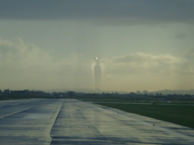
Below is a shot I took in Christchurch yesterday.
While my wife went shopping at dress mart I headed to the airport even though the weather was rubbish but always like taking photos no matter what the conditions as you never know what you might see.

This 777 basically blasted a hole through the cloud as it approached.
It was it approaching way out, it went behind some clouds and as it appeared again it tore a hole in the sky that looked quite neat.

Took several photos of other aircraft if anyone is interested in seeing them.


PostPosted: Sat Feb 28, 2009 8:31 pm
by Chairman
Wow that first shot is cool, I am so jealous !!! groupwave.gif

If only I lived a little closer to an airport, and had an extra 12 hours or so in a day .........

Gary

PostPosted: Sun Mar 01, 2009 7:36 am
by spongebob206
What a shot!

Thanks for sharing.

PostPosted: Sun Mar 01, 2009 9:19 am
by ardypilot
Wow impressive shot! That's what you get when you don't have winglets installed- you can really see those vortices clearly there.

I'm interested to know what conditions lead to them becoming so clearly visible, I know they are at their greatest size at low speed, but does moist air or low/high temperature have an effect?

PS- Was that a Singapore 77? We were watching one on radar at Auckland Tower inbound from Melbourne at about 9.30am yesterday, and it was about half way across the Tasman at that point.

PostPosted: Mon Mar 02, 2009 8:57 am
by HardCorePawn
Having been doing your CPL studies you should know the answer to your vortice question Andrew tongue.gif

PostPosted: Mon Mar 02, 2009 5:12 pm
by ardypilot
I know that low speed + heavy weight + no winglets = large vortices, but am unsure as to what makes them visible on somedays, not on others?

PostPosted: Mon Mar 02, 2009 8:53 pm
by towerguy
suggested study

pressure / temp

and then

temp / dewpoint

like most study - If I TELL you the answer then you know the ANSWER - if you WORK OUT the answer then you'll know the REASON.

PostPosted: Wed Mar 04, 2009 10:51 am
by cambridgedan
that first shot is really cool

PostPosted: Wed Mar 04, 2009 7:29 pm
by ardypilot
towerguy wrote:
QUOTE (towerguy @ Mar 2 2009, 09:53 PM) <{POST_SNAPBACK}>
suggested study

pressure / temp

and then

temp / dewpoint

Increase in temperature = decrease in pressure/density
Increase in dewpoint relative to temperature = increased chance of precipitation

According to wiki: 'The cores of wingtip vortices are sometimes visible due to condensation of water vapour in the low pressure', so in Gav's pic above, the air must have been pretty warm with a relatively high dewpoint? Correct TG? I thought these conditions would be fairly common at NZAA, but I've never witnessed vortices whilst watching low aircraft on the 23L approach from the lookout...

PostPosted: Wed Mar 04, 2009 7:52 pm
by 2fst4u
i hate to simplify things but he did say it flew through a cloud. clouds are just visible water vapour so the effect of currents and air movement (and vorteces) on them should always clearly visible. a suggested study from my point of view would be cloud cover/types vs vorteces visibility

PostPosted: Thu Mar 05, 2009 2:06 am
by towerguy
yes in this particular instance the vortices are visible due to the already existing cloud, however I was pointing out the reason they are visible in the situation of something on the approach,
ie when you see them formed off the wing tips or the edges of the flaps etc on the way down the ILS or on final as seen from the carpark etc.

The view in the photo is a very commonly seen one from here in the tower and only requires the presence of a cloud. The other is mostly prevalent in conditions of a close temp and dewpoint - cool winter mornings are great.

the reduction in pressure results in a reduction of temperature and condenses out the water vapour as a cloud and even forms rain, if the temp is already low enough then the trail can last quite a long time - to the point that on a near calm morning I have watched a heavy fly the 23ILS and actually spread a blanket of fog behind him! The same happens when the aircraft rotates on takeoff or flares in the landing - you get the brief flash of the entire wing covered in cloud/fog - you may have seen the photo of an F18 breaking the sound barrier with a cone of vapour surrounding him - same thing.

another thing often observed from the tower - waterspouts - formed by the vortices as they hit the water. occurs best with a full tide and a slow "heavy" on final for 05R on a day with relatively light winds. you can get 3 or 4 per side in a line slowly tracking across the harbour.

PostPosted: Thu Mar 05, 2009 3:41 pm
by 2fst4u
haha, im in no position to counter that argument. very informative. i do know what your talking about, sometimes when approaching wellington in 737's you can see mist coming off the wingtip but then dissapating quite instantly, so i doubt that would be visible from the ground. it all requres perfect conditions i suppose

PostPosted: Sun Mar 08, 2009 4:34 pm
by ardypilot
QUOTE
The view in the photo is a very commonly seen one from here in the tower and only requires the presence of a cloud. The other is mostly prevalent in conditions of a close temp and dewpoint - cool winter mornings are great.[/quote]
You're not lying- a b1900 pilot posted this shot taxing towards the 23L threshold on another forum:

PostPosted: Wed Mar 11, 2009 12:08 am
by dbcunnz
Some more unusual photos

CONTRAIL - 747


757 at Gatwick with wake vortex


757 showing wing vortex on clouds


767 wing vortex on clouds


340 rainbow contrail


EMIRATES A 380


FA 18 going SONIC


F 15E Strike Eagle


Camera at FL 340 , 747 at FL 350 , and B777 at FL 380


FL 330, FL 340-very dramatic-going opposite and 1000' separation


A 330 landing Amsterdam with dramatic sky

PostPosted: Wed Mar 11, 2009 12:57 am
by Ian Warren
Some extraordinary photos there , one other was a view across Wellington harbour .. the sea was a mill pond and across were the two lines generated by the wingtips .