Something different.
13 posts
• Page 1 of 1
![]() by Olderndirt » Mon May 30, 2011 6:44 am
by Olderndirt » Mon May 30, 2011 6:44 am
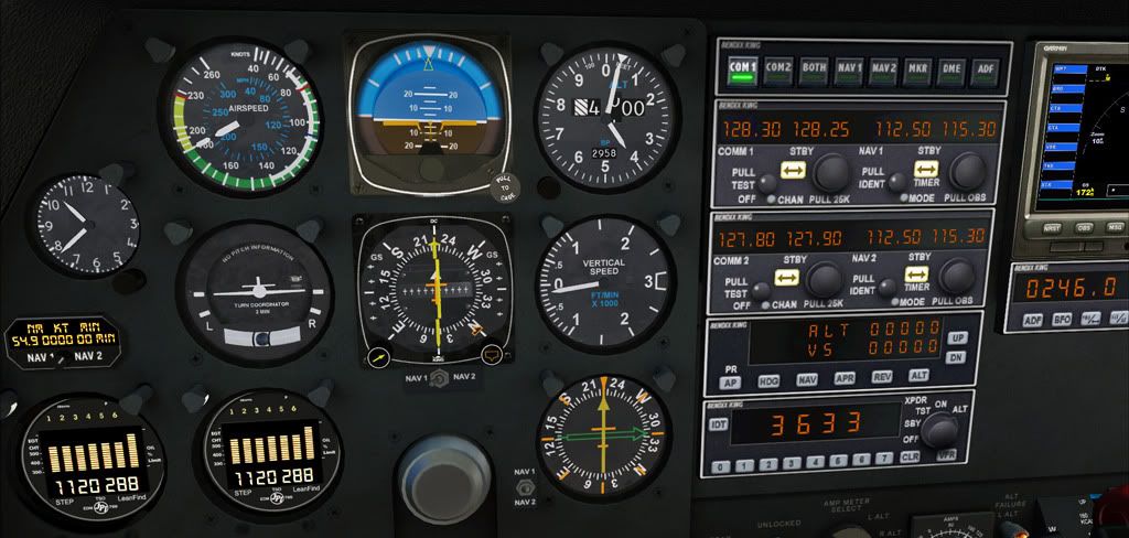
Finding my way around NZ, decided to try a little IFR. WHERE AM I? Clues - South Island and the ADF doesn't work.

-

Olderndirt - Senior Member
- Topic author
- Joined: Wed Jan 05, 2011 2:36 pm
- Posts: 1774
- Location: Rochester, Washington USA
![]() by connor » Mon May 30, 2011 8:05 am
by connor » Mon May 30, 2011 8:05 am
My first thought was Queenstown, thats where all your screens are from! 
But I think you are about 38 nm north of Timaru, 20nm south-west-west of Ashburton, inbound to the Mount Mary VOR.
But I think you are about 38 nm north of Timaru, 20nm south-west-west of Ashburton, inbound to the Mount Mary VOR.
- connor
- Senior Member
- Joined: Sat Nov 27, 2010 11:01 am
- Posts: 1616
- Location: Christchurch
![]() by cowpatz » Mon May 30, 2011 9:02 am
by cowpatz » Mon May 30, 2011 9:02 am
Yeah I would say about 15 miles SWW of Ashburton on the way to Mt Mary. By the way that VOR is scheduled to be decommissioned in Nov next year.
Last edited by cowpatz on Mon May 30, 2011 9:06 am, edited 1 time in total.
Remember the 50-50-90 rule. Anytime you have a 50-50 chance of getting something right, there's a 90% probability you'll get it wrong!

-

cowpatz - NZFF Pro
- Joined: Wed Mar 07, 2007 3:28 pm
- Posts: 3751
![]() by morrisman1 » Mon May 30, 2011 11:31 am
by morrisman1 » Mon May 30, 2011 11:31 am
I would be tempted to say 55 RY DME on the H476 inbound to mount mary but then I looked at your altimeter. That route has a MSA of 9800' so I hope you didnt hit any big mounds of dirt while in the clouds!
Cameron Morison
CAA CPL(A), MEIR
FSX Acceleration on windows 7 64bit, Gigabyte P55a-UD3R i5-750, 4GB DDR3, HD5850 1GB (and still sucky frames - thanks fsx!)
CAA CPL(A), MEIR
FSX Acceleration on windows 7 64bit, Gigabyte P55a-UD3R i5-750, 4GB DDR3, HD5850 1GB (and still sucky frames - thanks fsx!)
-
morrisman1 - Member
- Joined: Wed Jan 27, 2010 6:24 pm
- Posts: 87
![]() by Ian Warren » Mon May 30, 2011 11:35 am
by Ian Warren » Mon May 30, 2011 11:35 am
cowpatz wrote:QUOTE (cowpatz @ May 30 2011,10:02 AM) <{POST_SNAPBACK}>By the way that VOR is scheduled to be decommissioned in Nov next year.
Least we can still play around with it in FS , sorta like making sure Wigram never close,s


-

Ian Warren - NZFF Pro
- Joined: Fri May 05, 2006 5:23 pm
- Posts: 41187
- Location: AREA 51
![]() by Olderndirt » Mon May 30, 2011 12:42 pm
by Olderndirt » Mon May 30, 2011 12:42 pm
Oops! You seem unanimous about Mt Mary and I don't know nuthin' about Mt Mary. The chart I'm using came from a gent in Belgium and is dated 2003 - not an official chart but it has frequencies, courses and distances but no minimum enroute altitudes. If Mt Mary's synonimous with Pukaki, then you guys have me spotted 54.9 DME out on the airway Christchurch - destination. Need to get an IFR chart before I kill myself  .
.
.-
Olderndirt - Senior Member
- Topic author
- Joined: Wed Jan 05, 2011 2:36 pm
- Posts: 1774
- Location: Rochester, Washington USA
![]() by connor » Mon May 30, 2011 1:46 pm
by connor » Mon May 30, 2011 1:46 pm
Olderndirt wrote:QUOTE (Olderndirt @ May 30 2011,12:42 PM) <{POST_SNAPBACK}>Oops! You seem unanimous about Mt Mary and I don't know nuthin' about Mt Mary. The chart I'm using came from a gent in Belgium and is dated 2003 - not an official chart but it has frequencies, courses and distances but no minimum enroute altitudes. If Mt Mary's synonimous with Pukaki, then you guys have me spotted 54.9 DME out on the airway Christchurch - destination. Need to get an IFR chart before I kill myself
Yeah, Mt Mary is at the base of Lake Pukaki. So, did I get it right?
- connor
- Senior Member
- Joined: Sat Nov 27, 2010 11:01 am
- Posts: 1616
- Location: Christchurch
![]() by morrisman1 » Mon May 30, 2011 3:13 pm
by morrisman1 » Mon May 30, 2011 3:13 pm
H476 goes CH - ANOLA - RY (mount mary) and mount mary is at the base of lake pukaki, just on the eastern side on a hill. MSA is 9800 and where you are currently the lowest is 7200 (distance step 7200' within 60 dme of CH and 3500' within 40 dme CH but you are currently 45 DME CH)
Cameron Morison
CAA CPL(A), MEIR
FSX Acceleration on windows 7 64bit, Gigabyte P55a-UD3R i5-750, 4GB DDR3, HD5850 1GB (and still sucky frames - thanks fsx!)
CAA CPL(A), MEIR
FSX Acceleration on windows 7 64bit, Gigabyte P55a-UD3R i5-750, 4GB DDR3, HD5850 1GB (and still sucky frames - thanks fsx!)
-
morrisman1 - Member
- Joined: Wed Jan 27, 2010 6:24 pm
- Posts: 87


![]() by Ian Warren » Mon May 30, 2011 7:43 pm
by Ian Warren » Mon May 30, 2011 7:43 pm
Splitpin wrote:QUOTE (Splitpin @ May 30 2011,7:45 PM) <{POST_SNAPBACK}>...i get confused by the numbers these days (damm it)
Marty , don't worry , he's tuning into : Radio Avon 1290 !..... oops .. so last century
-
Ian Warren - NZFF Pro
- Joined: Fri May 05, 2006 5:23 pm
- Posts: 41187
- Location: AREA 51
![]() by Olderndirt » Tue May 31, 2011 7:36 am
by Olderndirt » Tue May 31, 2011 7:36 am
morrisman1 wrote:QUOTE (morrisman1 @ May 29 2011,8:13 PM) <{POST_SNAPBACK}>H476 goes CH - ANOLA - RY (mount mary) and mount mary is at the base of lake pukaki, just on the eastern side on a hill. MSA is 9800 and where you are currently the lowest is 7200 (distance step 7200' within 60 dme of CH and 3500' within 40 dme CH but you are currently 45 DME CH)Boy do I need a chart. Your avatar has some stuff indicating pilot ratings - I think. Ours in the U.S. are a bit different - mine all disappeared with my medical but it's like riding a bicycle, you never forget the basics
-
Olderndirt - Senior Member
- Topic author
- Joined: Wed Jan 05, 2011 2:36 pm
- Posts: 1774
- Location: Rochester, Washington USA
![]() by morrisman1 » Tue May 31, 2011 12:28 pm
by morrisman1 » Tue May 31, 2011 12:28 pm
Olderndirt wrote:QUOTE (Olderndirt @ May 31 2011,7:36 AM) <{POST_SNAPBACK}>Boy do I need a chart. Your avatar has some stuff indicating pilot ratings - I think. Ours in the U.S. are a bit different - mine all disappeared with my medical but it's like riding a bicycle, you never forget the basics
Im sure someone could help you out with a chart. Ive got two sets - the flight simming ones which are the 2010 charts and my flying ones which are 2011. Those letters mean commercial pilot licence for fixed wing and an instrument rating for a multi engine aircraft. I dont know how the system works in the states but also being ICAO I imagine that its pretty similar in operationCameron Morison
CAA CPL(A), MEIR
FSX Acceleration on windows 7 64bit, Gigabyte P55a-UD3R i5-750, 4GB DDR3, HD5850 1GB (and still sucky frames - thanks fsx!)
-
morrisman1 - Member
- Joined: Wed Jan 27, 2010 6:24 pm
- Posts: 87
![]() by Olderndirt » Tue May 31, 2011 12:45 pm
by Olderndirt » Tue May 31, 2011 12:45 pm
morrisman1 wrote:QUOTE (morrisman1 @ May 30 2011,5:28 PM) <{POST_SNAPBACK}>Im sure someone could help you out with a chart. Ive got two sets - the flight simming ones which are the 2010 charts and my flying ones which are 2011. Those letters mean commercial pilot licence for fixed wing and an instrument rating for a multi engine aircraft. I dont know how the system works in the states but also being ICAO I imagine that its pretty similar in operationPretty much. I had Comm/ASELS/MEL/Inst plus CFI ASE/Inst. Commercial, Single Engine Land and Sea, Multi engine land, Instrument - Certified Flight Instructor, Aircraft single engine, Instrument. Without a current medical it's just a little anodized plaque hanging on the wall
-
Olderndirt - Senior Member
- Topic author
- Joined: Wed Jan 05, 2011 2:36 pm
- Posts: 1774
- Location: Rochester, Washington USA
13 posts
• Page 1 of 1
Who is online
Users browsing this forum: No registered users and 37 guests